
Geomorphology and Physical Geography Research Group
•Assistant Professor Yoshinori Otsuki, specializing in geomorphology and natural environmental geography
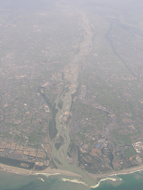
Figure 1. Depositional landforms near the mouth of the Tenryu River flowing into the Pacific Ocean. The river forms a low-gradient fan (also called a fan delta or coarse-grained delta). Borehole core sediment analysis can reveal how the landforms have responded to glacioeustatic sea-level changes.
One of the major fields of physical geography is geomorphology, the study of landforms over the entire surface of the Earth, including temperate zones such as Japan. It is fascinating to explore the geomorphological changes that occur in zones ranging from tropical to temperate to polar.
Our research group investigates how landforms are shaped and how long they take to form through field observation, borehole core drilling, topographic measurements, aerial photograph interpretation, satellite image analysis, and analysis of collected samples (e.g., grain size, tephra, macrofossils, microfossils, and radiocarbon dating). Our group also focuses on reconstructing the Quaternary period, investigating environmental changes such as sea level and climate through the analysis of sediments taken from delta, lake, and shallow sea bottoms.
We focus mainly on the following topics.
- The relationship between the evolution of coastal and fluvial landforms in Asia including Japan, and sea-level and climate change during the late Quaternary, especially since the last glacial maximum (Fig. 1).
- Slope form and processes in humid regions and tropical highlands (Fig. 2).
- Soil erosion and desertification in arid and semi-arid regions (Fig. 3).
- Landform change and sediment transport caused by geological hazards such as landslides, floods, and tsunamis (Fig. 4).
Geomorphological research helps to deepen our understanding of Earth's surface environment. The knowledge gained through geomorphological research is useful not only for disaster prevention and mitigation, but also for studying the landforms observed on the surfaces of other planets.
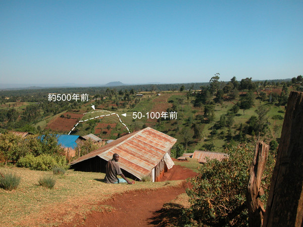
Figure 2. Valley-side slopes in the tropical highlands in Kenya, East Africa. Shallow landslides can occur on these slopes, mainly twice a year during the rainy season, sometimes causing disaster. As shown in the figure, there are 500-year-old and 50- to 100-year-old landslide scarps in close proximity. This indicates that the valley-side slopes are maintained and renewed by such repeated landslides.
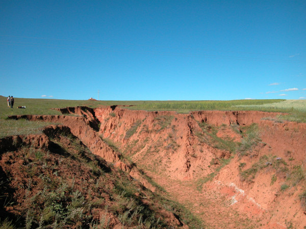
Figure 3. Soil erosion in central Inner Mongolia, China. This is a semi-arid area with grasslands where no forests can exist due to the relationship between the annual precipitation of ~350 mm and the mean temperature of 2.5°C. Even with little rainfall, the overland flow erodes the gentle slopes, forming a gully and causing sediment to flow out. The gully currently continues to extend at a rate of ~1 m/yr, reducing the area of the grassland and cultivated lands.
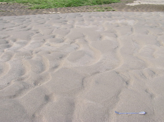
Figure 4. Sandy sediment covering paddy fields along the Asuwa River during the heavy floods in Fukui in July 2004. The direction of flow can be estimated by examining the bedforms and the direction in which rice plants have fallen.